Recent papers add to the growing and most watery weights of evidence which may signify a persistent and robust contribution of Solar Cycles to the expansions and contractions of Himalayan ice fields/glaciers within our geostrophic atmosphere. Or maybe not. This is only a blog which explores solar hydroclimatological signatures routinely. Should the limb of this exploration fail, this post can be edited to capture that failure in the future.
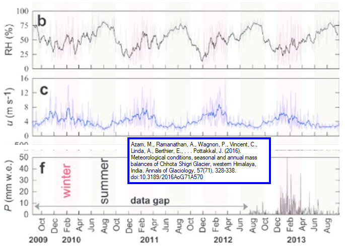
First and foremost, attribution of this post’s fair-use of the featured image excerpt is paid to Arindan Mandal, who is among the joint authors of several interesting and useful papers on key Himalayan glacier mass balances of recent vintage [1]. I’ve excerpted the Relative Humidity (RH), wind speed u, and precipitation p from that paper. The paired images below corroborate that precipitation across that locale is almost nonexistent over each monsoon. It is also clear to me at least that gyre-like and relatively stagnant geostrophic flow conditions prevail across the summer monsoons and those are replaced by Westerlies through the winter. This geostrophic framework is featured in the following two hydroclimatologic images for the featured Himalayan glacial seeding zone within the thin yellow outline.
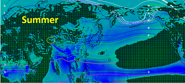
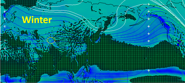
As typical for this site, the full atmosphere Evaporation minus Precipitation (EP) signature is featured and the deepest blues (and lowest apparent surface elevations) reflect the highest monthly climatological precipitation [3]. In this orthogonal surface view, I aligned so that the zero elevation is the plane which the green lattice surface emerges from. I added streamlines with origins indicated by white stars. The streamlines are constrained to hug the EP=0 surface.
Each component separately and in combination invites reflection and comparison to the featured image that I excerpted from [1]. I like to think of the green surfaces as analogous to foam which floats and circulates within the eddies of the system. They only persist for example, where it is not largely raining or snowing.
This makes them a good index for viewing the area covering the Himalayan glaciations of concern highlighted by the featured paper within the yellow oval. Clearly in Winter, the Chhota Shigri glacial seeding zone receives most of its moisture. Accordingly the monsoon has little impact on this, but rather the prevailing Westerlies.
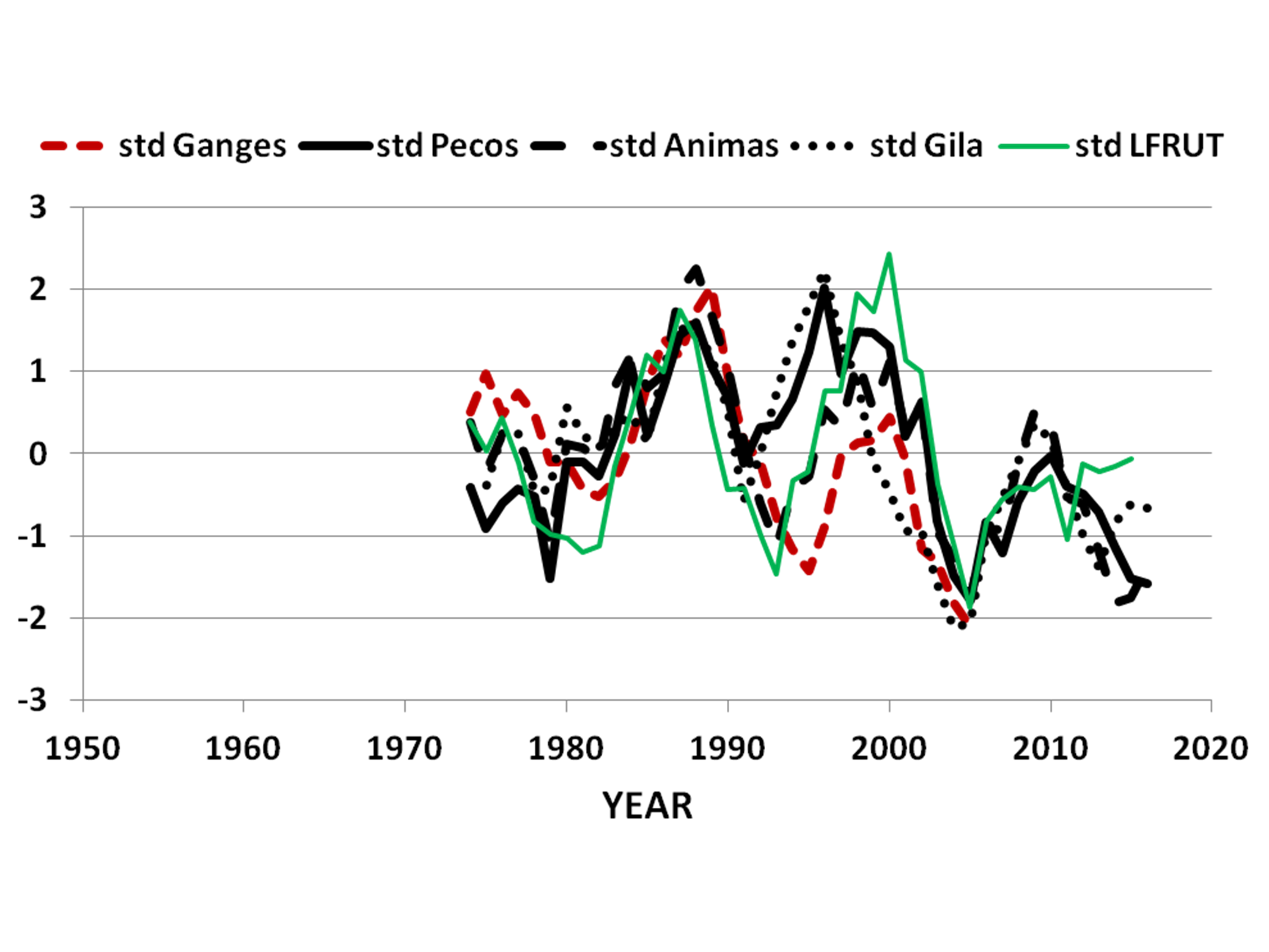
It is recognized that the Westerlies-versus-Monsoon dynamic holds also for the American West. But the actual and most interesting similarities in at least some streamflows has only recently been introduced to the best of my knowledge. My paper last year [3] featured this image to capture an observation that at least over 60 month spans, the flows of rivers from the Himalayas paralleled the flows of some streams of the Southern Rocky Mountains, including the Animas River.
With respect to the hydrographs and geostrophic resources featured here and in other posts, the new featured time series excerpt from [1] appears to be in alignment. Notably, the Himalayan precipitation is only significant within the yellow outline (roughly) over the Winter period, when the Westerlies dominate. I also find it interesting that the resource of [1] includes a Temperature time series which closely parallels the moisture time series.
In any case Temperature and Moisture are always recognized to be related, especially within the demanding meteorological forecast community. Now Himalayan and Rocky Mountain river flows are recognized to be related with the hydrological forecast community. It is no surprise as well that both are closely related to sediment transport and surficial geochemistry. I look forward to a more detailed examination of a potentially very supporting paper again on the Chhota Shigri glacier and chemical based mass balancing [2]. Given all of these, and many additional supporting connections, unless a new counter paper to [3] comes to the dominant peer reviewed universe, I guess that Solar Cycles are related to Himalayan Glacier expansions and retreats.
Perhaps a flood of new papers will make my scratches seem quaint. I can already see the previous and seminal scratches of others such as [4] which among other things also represents that solar cycles can correlate to temperatures over glaciers. I want to keep this recurring observation in mind as my own explorations of solar causation advance.
I think the incremental benefit of this short post is to further corroborate a solar driver for contemporary glacier advances and contractions. In the previous post I explored the same solar and moisture glacier driver for the millenial spans of recent Ice Ages. In any case, I’ll continue to focus on geostrophic moisture in everything glacier because of the growing and most watery weight of corroborating evidence to support.
References:
[1] included feature image fair use: Azam, M., Ramanathan, A., Wagnon, P., Vincent, C., Linda, A., Berthier, E.,Sharma, P., Mandal, A., Angchuk, T., Singh, V.B., and Pottakkal, J. (2016). Meteorological conditions, seasonal and annual mass balances of Chhota Shigri Glacier, western Himalaya, India. Annals of Glaciology, 57(71), 328-338. doi:10.3189/2016AoG71A570
[2] (2019) Switch in chemical weathering caused by the mass balance variability in a Himalayan glacierized basin: a case of Chhota Shigri Glacier, Hydrological Sciences Journal, 64:2, 179-189, DOI: 10.1080/02626667.2019.1572152
[3] (2019) Application of lagged correlations between solar cycles and hydrosphere components towards sub-decadal forecasts of streamflows in the Western USA, Hydrological Sciences Journal, 64:2, 137-164, DOI: 10.1080/02626667.2019.1567925
includes charts and maps from ERAI resources at UCAR for the monthly integrated full atmosphere thickness of Evaporation minus Precipitation, Temperature, Divergence of latent energy, zonal and meridional winds, and Geopotential Height. 36 years to the end of 2014.
[4] B. Nurtaev. 2016. Impact of Solar Activity on Hydrological Cycle of the Himalayan and Indian Penninsula Rivers. Institute of Helioclimatology, Germany. ISSN: 2333-2581. Modern Evironmental Science and Engineering. http://www.academicstar.us/issueshow.asp?daid=1323