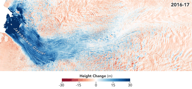
After shrinking from an apparent high in the 1980s, the signature Jakobshavn Glacier, advancing into a slushy bay along the west coast of Greenland, has been growing rapidly over the past few years. The featured NASA [1] animation speaks for itself. Although a lateral scale is missing, I also commend the authors and other contributors to the animation for its clear and beautiful framing. Context that relates to that news can be followed for previous posts within this site on glaciers (some which have noted Jabokshavn changes) or other resources one can find independently. Here is a recent example:
One can become confused by contradictory pronouncements by Glacier scientist Josh Willis, whom I’ve quoted in some of those past posts last summer. If I were to blend the media sources which interviewed him around that time, the Jacobshavn Glacier has been simultaneously growing and shrinking.
Only a blog.
I think I see the path forward to reconciliation. Glaciers can grow and shrink at the same time for one thing.* In that respect, glaciers are not unlike clouds. It’s nothing strange, because both are made primarily of water. In fact ice can be found in most if not all clouds and it dominates in many types. For that matter, liquid water can be found at glaciers. One main difference is simply that obviously glaciers are more stationary than clouds. Some hydrologists might also agree that the same moisture condensation and nucleation process apply to both glaciers and clouds, without any scale dependency. Think of the ridges and tips of mountains emerging above the 3 km thick underbelly of our atmosphere. Those are loosely speaking, nucleation points for higher altitude circulating moisture to condense around.
Maybe my own background as a nanoscientist and hydrologist leads me to think of giant mountain ranges as if they were little different in some ways than any tiny floating water or ice nucleation particle in the atmosphere. Concepts like these are overshadowed by the “orographic effect” term and that is certainly fine with me and other scientists from a practical standpoint. Orography and winds both moist and dry, are potent factors which add predictability to precipitation including snowfall over mountain catchments on a day to day basis. It is the the multi-year prediction problem which hasn’t been resolved yet.
One might be left thinking that since clouds cannot be predicted over decadal time spans, then glaciers cannot either. But I can now cite [2] and indicate that if one doesn’t seek perfection, clouds are not always unpredictable. That reference happens to document statistically significant, lagged correlations between solar cycles and the decadal-scaled growth and retreat of clouds across key patches above the tropics. The paper accomplished that by correlation against the Outgoing Longwave Radiation (OLR) measurements across the targeted equatorial west pacific footprint. Basically as well known by relevant experts, the greater the cloud cover, the lower the OLR. This is simply because the clouds block radiant energy from the planet’s surface from reaching space (where the satellites are).
Because of the lag of a few years between solar cycles and the OLR record, and given the high correlation, I can argue that Clouds are predictable, years in advance, within the proper framework and locale. In any case, I may be on the same page with others who could assert that both condensed moisture receptacles, glacier and cloud, are formed from good old-school physical water state changes in a flowing otherwise relatively dry atmosphere.
And any can confirm that for several decades since the onset of the satellite era in the early 1980s, Jacobshavn had been shrinking. There then remains the questions of why. I think the sum of this site collectively points to a solar-hydrosphere forcing answer.
Regardless of any natural temperature cycle, it always takes water recharge to sustain and grow any glacier or cloud. The mid 1980s were a period where, in signature regions of the Northern Hemisphere, the circulating atmosphere was relatively moist, not dry. When the atmosphere is relatively moist, there is a relative increase in streamflow. Accordingly this older post of mine featured below, gives a convenient time series of some Rocky Mountain streams, which I can deploy as surrogates for atmospheric moisture of at least the middle latitudes of the northern hemisphere (which I can then try to compare to glacier patterns).
By the way, readers may wish to disregard the red time series featured above. That official National Climate Assessment simulation run is nothing like the other curves, which are based on actual USGS streamflow data for the southern Rocky Mountains. In fact that red curve and its hundreds of synthetic kin are not like anything observed in actual streamflow observation data, as the link above and other posts begin to explore.
The other smaller curves in that image link do reflect real data, and they support my point above. Glaciers cannot thrive without water recharge, and there was simply more atmospheric water swirling around in the Northern Hemisphere and sandwiching the Jet Stream in the mid 1980s, when the Jakobshavn Glacier was larger. This is not controversial from a data perspective as many posts at this site support as well as my own recent publication in this field [2]. However for my part I’d like to revisit atmospheric moisture assets for the satellite era and overlay to glacier remote sensing assets more directly, and covering each hemisphere. I could start with an inclusion of this asset showing Geopotential Height (Z) across the first decade of the satellite era.
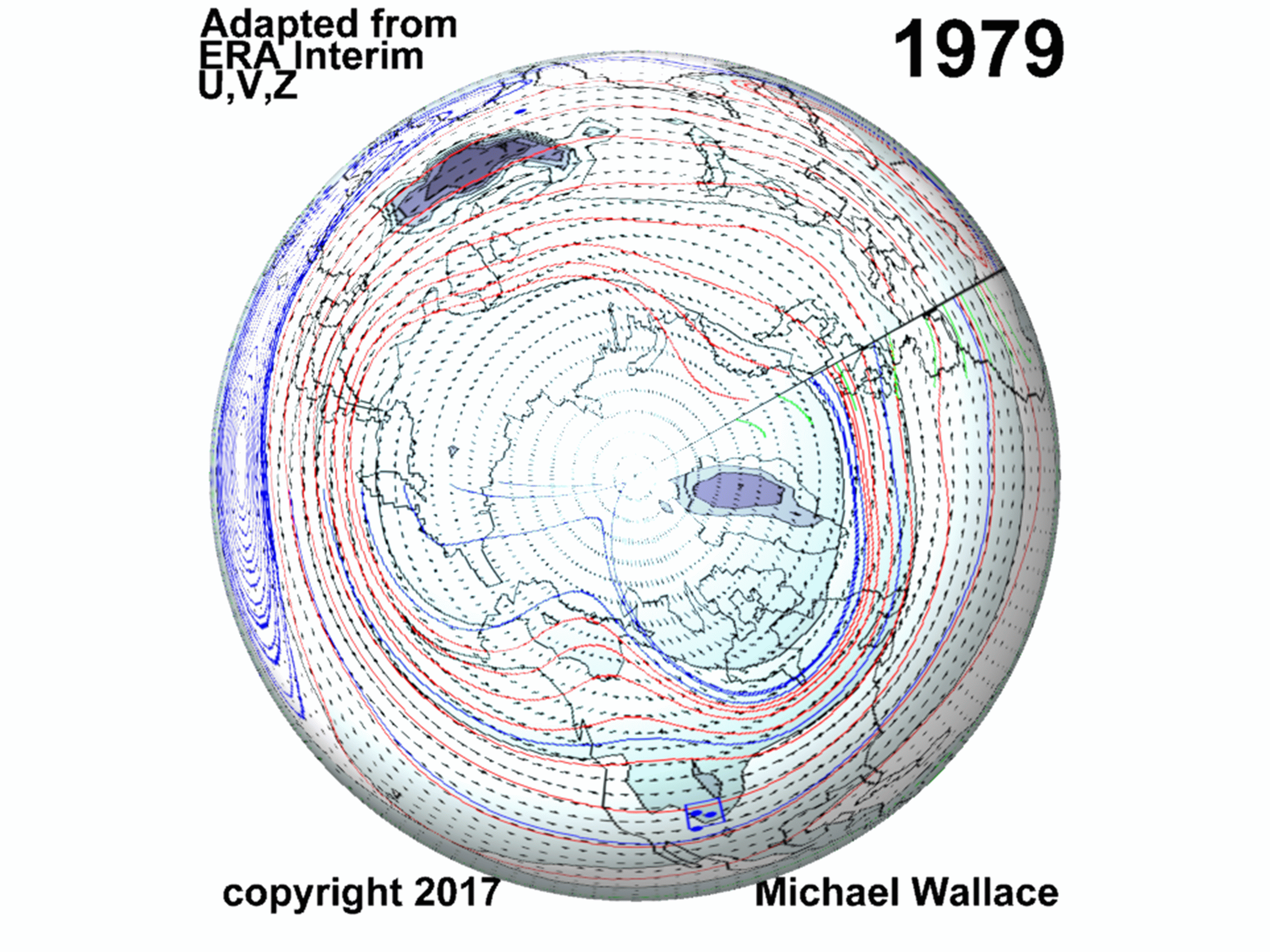
MWAappliesQGprinciplesExample_079
This was an older asset but happens to help me and perhaps others have a fair means of comparing glaciers across the northern hemisphere with annual contour plot representations of Z, and vector and streamline plots of flows. For example, the Jakobshavn can be found at the notch along the middle of the west coast of Greenland.
Through the Hypsometric Equation, Z relates conveniently to both Temperature and Pressure. Accordingly where it can be applied Z also conveniently relates to Water content, because pressure drops dramatically as atmospheric water content rises (as many know).
In short, the darker the blue/gray color, the greater the relative moisture content in the full thickness of the atmosphere. It is also interesting to see things such as the Jet Stream where the streamlines converge, and with care some might be able to note the areas where general atmospheric flows are barotropic or baroclinic, for what that may be worth.
I’ll follow up with more because the overall treatment of glaciers in the academic and establishment research community is clearly piece-meal. Those of us who wish some easier means to corroborate their consensus glacier growth assertions could benefit. This might help even those researchers to explore whether it was actually only solar and water which have been driving the patterns of glacier development everywhere, all of the time.
Discussion
I had been producing accurate multi-year forecasts of some Rocky Mountain streams using the method I premiered in [2]. That link shows that Rocky Mountain streamflows within my study had been decreasing overall since the 1980s. The link also shows that I predicted an uptick in moisture which was to begin around 2016 and persist for several years. This is turning out to be true, 3 years into the actual forecast.
My multi-year streamflow prediction still has a few years to go and perhaps the performance will improve or degrade by the end of the span. In any case it is interesting to me that much like those Rocky Mountain steams, the Jakobshavn Glacier had been declining since the 1980s, and now has been growing for the past several years.
a draft
References:
[1] https://climate.nasa.gov/news/2882/jakobshavn-glacier-grows-for-third-straight-year/
Image source: https://climate.nasa.gov/internal_resources/1850/
[2] Wallace, M.G., 2019, Application of lagged correlations between solar cycles and hydrosphere components towards sub-decadal forecasts of streamflows in the Western US. Hydrological Sciences Journal, Oxford UK Volume 64 Issue 2. doi: 10.1080/02626667.2019.
*Of course this is not what Dr. Willis meant. I could speculate on what he meant, but perhaps helpful if I reach out to him to explore more directly. I only offer this cloud – glacier comparison because it is interesting.