The use of the Pacific Decadal Oscillation (PDO) to aid in forecasting streamflow in the Upper Rio Grande, may be a viable alternative to reigning forecast methods. For example, the SNOTEL-based USDA NRCS New Mexico Basin Outlook Report May 1, 2014, which disregards the PDO, states:
“Much like the last few years, as of this final Basin Outlook Report for 2014, it looks like New Mexico is going to have an extremely low runoff year for the most part with the peak runoff probably having already occurred for most of the state”
and later in the same report:
“In a pattern similar to the last couple years, although snowpack levels have been dropping throughout March and April with many areas seeing most of the snowpack already melted out, streamflow volumes have not consistently increased proportionally; indicating sublimation and infiltration losses are occurring. It should also be noted that melt-out is happening several weeks ahead of normal for many areas. “
This assessment is a stark contrast to what can be seen from a methodology grounded in the PDO. Before I begin, I take this moment to note that as of this day, 25 May, 2014, it appears to be snowing in the headwaters of the Upper Rio Grande in the San Juan mountains.
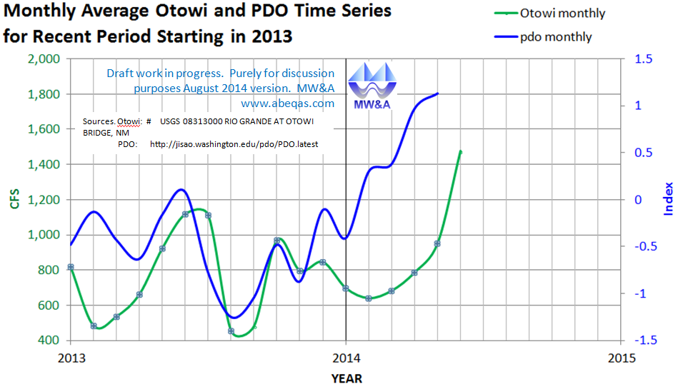
Past recent posts at this web site show that the Otowi gage correlates over 4 year and 10 year trailing averages to the PDO. Now I take a look at a much smaller time frame and I avoid the use of moving averages. In so doing I am well aware that even high correlations may be spurious. Again this is only a demonstrative exercise to give food for thought.
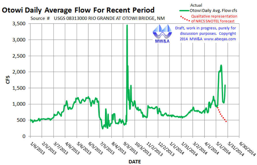 The first image covers daily averages of the Otowi gage flows since the beginning of 2013. This can be viewed in context of the SNOTEL report. A wet May was simply not anticipated via their approach. The SNOTEL forecasters also expressed a high level of certainty as to where significant amounts of water had disappeared to.. ‘indicating sublimation and infiltration losses’. This may be because they disregarded the relatively high level of snowpack in the Colorado parts of the Upper Rio Grande headwaters. I am not certain of this, but there is no mention in the report of those headwaters.
These plots indicate that flows are increasing overall since the beginning of 2013, and this is a different conclusion than the SNOTEL assessment. Moreover, had this been assembled in April, it would have been suggestive/predictive of a wet May (which is now a historical fact).
 Does this mean that chances are good for the remainder of 2014 that that Otowi flows will rise as the PDO rises and that the Otowi flows will fall as the PDO falls? Stay tuned. The final image is from a quick hike I took yesterday, Memorial Day May26, 2014, in the Sandia Mountains of New Mexico. Clearly, the SNOTEL forecast was wrong with regard to streamflows and snow events for this season.
Disclaimer: The information sets provided here, including all graphics, text and underlying calculations, are purely for demonstration purposes. MW&A is not responsible for any errors and/or omissions associated with any aspect of these demonstrative products. Moreover, MW&A is not responsible for any use of these demonstrative products by any other party regardless of purpose.