The major ocean gyres are relatively easy to automatically illustrate so long as quasigeostrophic perspectives remain paramount. Visualization of these circulatory limbs over ranges of moving averages, from monthly to multiple decades, can be achieved with the aid of particle tracking. The featured image is excerpted from an ongoing exploration of ERA Interim derived averaged integrated zonal and meridional wind velocities over a sample time span across the globe. The contours of Z geopotential height for the full atmosphere from the same ERA Interim source are included as well. Further details of this draft image are available upon request and/or will be augmented over time. In viewing these animations, please note the disclaimer at bottom of post and the context of the post.
The featured animation expresses various trajectories and relative velocities of hypothetical full atmosphere-averaged air parcels (symbolized by the red dots). Note that the velocity field is held constant for this simple comparative trajectory demonstration. Hurricanes are not depicted, although the eyes of many hurricanes are roughly the same size as the red dots. If hurricanes in the west NH Atlantic were rendered over time, they would be confirmed to rotate counter clockwise even as their trajectory takes them in a clockwise path over their lifetimes. A second animation follows for a month in which numerous hurricanes were reported.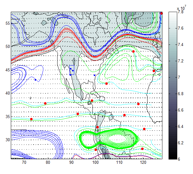
This is for July, 2014. This image is rougher and only captures three frames. However the equatorial easterlies, middle latitude westerlies, and some aspects of gyre circulation can be seen. Notably the tracks of the NH Atlantic gyre for this month are in apparent alignment with trajectories of hurricanes in that lobe at that time. This can be explored and approximately verified via the Wikipedia page:
Readers might also find it interesting to compare this animation to a previous post in which the counterpart and much larger northern hemisphere (NH) west Pacific Gyre is shown. The quasigeostrophic air parcels exit the NH Atlantic Gyre to the north and proceed east. Meanwhile the particles in the NH Pacific gyre exit to the south and proceed west. This arrangement is roughly mirrored in the southern hemisphere (SH). Mass balance is thereby preserved quasigeostrophically.
The circulation and vorticity mapping of the QG continuum are also consistent with Hadley Walker circulation dynamics papers and maps by numerous authors. It also seems possible within the narrow QG focus that momentum balances can be achieved in examinations of all or any subsets of this data*.
Between multi scaled resolution mass and momentum balanced QG data sets, along with other tools in our wheelhouse, MW&A plans to develop a limited set of reproducible cyclonic forecasts and hindcasts for multiple lead times and multiple Hadley Walker circulation profiles.
Currently, a comprehensive go-to site for hurricane prediction performance across the range of published forecasts is not available. Accordingly as is my custom with other hydroclimatological features, I will begin to profile and compile resources related to such forecasts which are available, even as I attempt to initiate some of my own forecast exercises.
Soon a preliminary graph compilation of recorded storms and hurricanes of interest to the NH west Atlantic.
Once the historical inconsistencies are resolved, an auto regression based forecast will follow as a surrogate for limited comparison of other forecasts.
As I work on that, I can note that NOAA does include disclosures of their track record on reporting the accuracy of these forecasts. I am consolidating this material along with information on hurricane forecasts by others and will pour that information into this post or a later one when time permits.
NOTES: In this preliminary demonstration, the time span for the particle tracking is not specified, even though the time span used for the geopotential height average values are (one month in this example) as well as the zonal and meridional full atmosphere average velocities. Therefore the animations are only suitable for selective relative comparisons between profiled full atmosphere parcel particle tracking (red dot motions).
No global circulation models (GCMs) were used in the development of this post.
*Often cyclones are described as if they do not express conservation of angular momentum but that appears to be more of a question of whether the momentum is perfectly balanced or slightly out of balance.