For the second year in a row, MW&A has utilized its unique ocean driver approach to produce hydrologic 9 month forecasts which include projections of moistening in advance of equivalent government sponsored forecasts (gsf).
For example one can consider this gsf made on January 7 of this year (2015) from the National Water and Climate Center (NWCC) as reported in the Albuquerque Journal:
The claims of a “fifth consecutive dry year” ahead persisted even into April of this year:
http://www.abqjournal.com/566999/news/rio-grande-water-users-in-for-another-tough-year.html
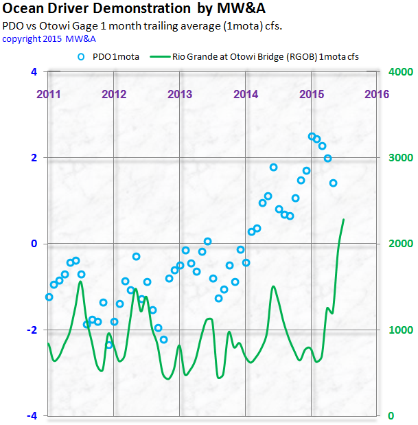
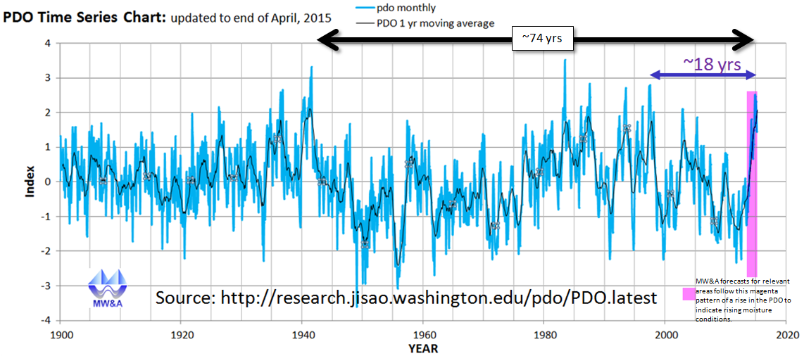
Given what is demonstrated by the charts above and below, the NWCC’s projection of a 5th year of drought was made, even as the PDO reached a monthly peak that hasn’t been seen in nearly 20 years, along with an annual peak that hasn’t been surpassed for the last 74 years.
The forecast methodology of MW&A, based on correlations to ocean drivers, has led to a different projection, and that has proven out once again. Reservoirs are filling, and the Rio Grande in New Mexico is transmitting abundant quantities of water. This is to be expected in line with the swelling PDO, as numerous posts here document.
One of the many paradigm difference between our method and the mainstream, is that we do not rely on snow pack estimates. Since we align our projections to ocean drivers with high correlations, we can forecast 10 year trailing average cfs values for any US Southwest stream, for both Spring and Summer, without waiting for the first (or last) winter snow to arrive.
Our latest quarterly forecast installment is now available * and includes numerous additional streams to our initial complement:
Green River in Utah (a major tributary to the Colorado River)
Arkansas River in Colorado
Canadian River in New Mexico
Santa Fe River in New Mexico
For discussion purposes and in context to the above, we are providing a qualitative and conditional forecast below. Please note that this is an occasional feature of our standard service.
If the rise of the PDO is sustained over the next several years, then MW&A projects an associated and significant rise in streamflows for the Upper Rio Grande and its tributaries, as well as the Navajo River, the Upper Pecos, and several other streams in the US Southwest in which the correlations to the PDO are significant.
Historically a ‘sustained’ surge in the PDO lasts from 3 to 5 years. Also historically the lag between the prominent ocean driver and these streams ranges from 6 months to 3 years. We accordingly apply that lag range to our projection. If the PDO rise is not sustained, then we don’t expect a sustained surge in the streamflows of note.
Please click on image for a scientific animation of this effect based on actual data.
*MW&A applies our unique approach, grounded in best stochastic hydrologic practices, in producing these forecasts, and in analyzing past forecasts and forecasts by others. MW&A makes no further representations on forecast performance or accuracy. Buyers are cautioned and advised to treat all hydroclimatologic forecasts as exercises which although based on quantifiable data, are nonetheless subject to extensive uncertainty.
We strive to ensure that our forecasts are quantitative, transparent, and traceable. For example, we don’t simply claim that an area will get wetter or drier. We also produce quantitative estimates.
MW&A does not change forecasts once they are published in our quarterly subscription journal, unless we must correct an error and then we disclose the error along with the correction.
We also clearly document our performance metrics to all subscribers.