Hurricane Forecasts by MWA, 8 Years in Advance
I recently began to explore the state of the art in high performance, multi year lag hurricane forecasting, as I carried out ongoing research in global hydroclimatology [1]. A few authors I have read include Goldenberg et al [2], Klotzbach [3] and Gray et al [4], and many thanks to Bob Endlich and Bernie McCune of the Cruces Atmospheric Forum for recommendations. Many of the products I examined show high accuracy as well as comprehensive and reproducible performance documentation.
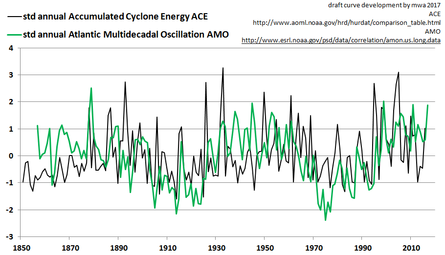
Their success may have something to do with the extraordinary time series comparison profiled in the featured image. This image appears to confirm and illustrate experts’ views regarding connections between the Atlantic Multidecadal Oscillation (AMO) and the north Atlantic’s Accumulated Cyclone Energy (ACE ), including recent NOAA content by Dr. Christopher Landsea.
The AMO and the ACE are somewhat synchronous on an annual scale. Therefore to date, all of the sometimes highly accurate forecasting examples appear to have been limited to better hurricane forecasting on a seasonal time scale. Examples of advanced accuracy hurricane forecasting on any scale beyond multi seasonal may appear hard to come by.
One exception can be found at
http://www.cfanclimate.com/COR
Those authors appear to forecast 1.83 cyclones per year on average hitting the U.S. coast over the five year time frame of 2011-2016 if a selected AMO state prevailed. My informal review of the observation record indicates 1.8 cyclones per year hit the U.S. coast on average over that period. That referenced pdf accordingly documents an excellent forecast by any standard, even if it was conditional upon an AMO state. Since that state prevailed, the 1.8 value from their table is also notable, and sets a high bar for any rival credible forecasts for that average and time span.
Perhaps now in addition forecast spans can be extended several further years beyond 5. This is likely in part because of the connections between the AMO and ACE along with the new development of forecasting the AMO at relatively high accuracy at high lag (8 yrs), for mid-decadal moving averages (5 year avg, disclosure: said forecasts by this author).
The following chart documents a related but somewhat less dramatic exercise. The ACE is projected based on a conventional autocorrelation technique (AC) and upon our quasigeostrophic (QG) informed method. The QG method does lead to the best forecast performance metrics of the two techniques surveyed, but further improvements are desired. In the interim, these mildly accurate multi year forecasts may reign as the best in their “class” (relating to average 5 year time span and 8 year lag for forecast, along with starting and ending dates, and target identification)
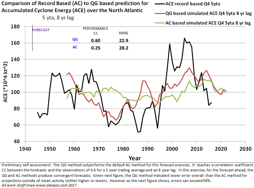
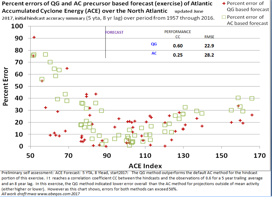
As annotated in the figures, the accuracy of each forecast value over this lag and moving average, appear so far to be higher for the QG informed predictor when the energy signature dipped or rose above the average. In other words, the QG methodology appears to best perform, relative to the AC method, when variability is expected to be greatest.
This is only a limited comparison. I plan to update accordingly over time.
My first addendum follows.
SEASONAL (as opposed to annual or decadal) hurricane, cyclone energy, and landfall forecasts continue to advance and improve via such sources [3], [4], and this just emailed to me by Dr. Judith Curry. In that link her firm projects 3 U.S. landfalls for the remainder of 2017. Also for context, I have extracted a few relevant seasonal forecasts of the ACE from NOAA’s HURDAT site in this image below. They project another north Atlantic hurricane season within their “High Activity Zone”:

As the graphic indicates via my annotations, in 2005 NOAA projected an ACE slightly under 200. The actual was approximately 270. The error is approximately 25%. This also fell within the “High Activity Era” targets clearly identified by the forecasters. Accordingly that past forecast can be considered successful with respect to a predefined activity state target. Naturally one would like to know the record of each ACE forecast produced, within a simple resource. Because that is not currently provided so far as I know, I have only looked at one past year on this parameter ACE, from this forecast provider.
In summary for SEASONAL classes, two sets of external hurricane related seasonal forecasts were explored. Past forecasts (where available) were also spot checked for documentations of past forecast performance skill. Skill results were found to be relatively excellent. The targets were clear, and the forecasts hit the targets. It is recommended for greater transparency among the two forecast entities mentioned in this addendum that they enhance their documentation by following the examples of Gray et. al [4] in which the full performance record of forecasts over time are integrated into a simple set of graphics and tables. Or they might consider the example I produced above which includes a full time series and several performance indicators in two simple graphs. Clearly there are many methods possible for those who wish to improve the transparency of their forecast performance record.
MULTIYEAR forecasts will no doubt to continue to advance on many fronts. MW&A appears to uniquely produce accurate multiyear forecasts of the AMO. The AMO has been identified by many to be a key precursor to hurricane features such as the ACE. MW&A will also work to dovetail our unique multiyear AMO forecasts and related to all reproducible cyclonic data and forecasts where value can be added within strategic partnerships.
Footnotes
[1] see past posts at this site such as Atlantic Gyre Example I also produced this post on Indian Ocean cyclone counts and sunspot numbers of the mid 19th century
[2] Goldenberg, S.B., C.W. Landsea, A.M. M-Nunez, and W.M. Gray, 2001, “The recent increase in atlantic hurricane activity: causes and implications” SCIENCE Vol. 293
[3] Klotzbach, P.J. 2007, “Revised prediction of seasonal atlantic basin tropical cyclonic activity from 1 august” Weather and Forecasting Volume 22
[4] Gray, W.M., C.W. Landsea, P.W. Mielke, Jr., and K.J. Berry, 1994, “Predicting atlantic basin seasonal tropical cyclone activity by 1 June” WEATHER AND FORECASTING Vol. 9, 103-115 American Meteorological Society
[5] http://www.aoml.noaa.gov/hrd/hurdat/comparison_table.html
These draft forecast sets and commentaries are produced for demonstration purposes only
 6349total visits,1visits today